I have tried not to post anything political on my blog. I have tried to keep it informational about Baltimore and the great state of Maryland, where I was born. But the marker on Trump’s golf course just pisses me the hell off and he really needs to remove it damn thing or at the very least put up an accurate one. I suspect he may be a bit of a Civil War buff who never had the chance to read on the subject. His family wasn’t in this country during that very bloody conflict. Neither was part of mine. But I’m from Maryland and the Civil War seems to be what we do here. I am by no means an expert, but I do have an extensive CW library and I love to read. If there are questions, I can always find answers, or if I can’t, I can find someone who can give them far better than I can.
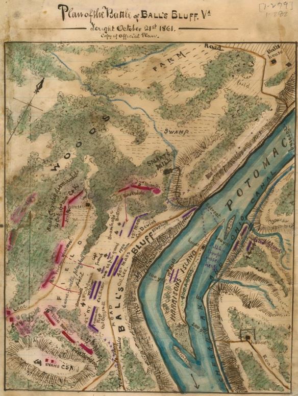
Between some of my ancestors that fought, and my uncle who had a dental practice in Leesburg, I pretty much know about the Rout, er….. Battle of Ball’s Bluff. It began as a minor reconnaissance misson in October 1861 to determine whether Confederate troops were still skulking around Leesburg. Earlier that year the Union Army had had its ass royally handed to it on a platter by Stonewall Jackson at 1st Bull Run and congress was still trying to figure out what the hell had happened. There had been reports of Confederate troop movement and General McClellan (yes – THAT McClellan – the one Lincoln eventually fired) assumed that meant that they had pulled out of Leesburg. They had, but not with any sort of permission. Under the command of Colonel Nathan “Shank” Evans, a known drunk, they had marched out on his orders alone. General P.T. Beauregard found out and was naturally annoyed and immediately ordered him back. Evans returned and set up his Mississippi troops along what is now Route 7, east of town and simply waited.
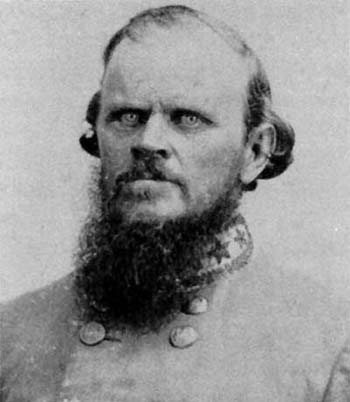
Colonel Evans – photo from Wikipedia (I think he’s positively creepy looking)
McClellan then ordered General George A. McCall out to map roads in the area and see about troop movement. He also ordered Brig. General Charles P. Stone to conduct a what he called a “demonstration” to see how Confederate troops would react. So they came across the Potomac at Edwards Ferry (south of White’s Ferry) and fired artillery into what they thought were Confederate positions. Nobody responded, so Stone had the Union troops withdraw. Stone figured the demonstration was over. No one in gray cared enough to respond. Truth is Evans probably wasn’t back in position yet. Stone then ordered about 20 men from a garrison stationed on Harrison’s Island (the Potomac is wide enough at that point that there is an island in the middle large enough to garrison troops) to re-cross the river into Virginia and scout around. These were men from the 15th Massachusetts under Colonel Charles Devens. Largely inexperienced, they mistook trees for Confederate tents and without verifying what they saw, (okay – how the hell do you do that?) reported back to General Stone – who of course ordered 300 men across the river to raid what they thought was a camp. Oops. To complicate things, the troops with General McCall had been ordered back to D.C. and apparently nobody knew this except General McCall.


Left to right – Colonel Devens, General Stone and General McCall. Photos from Wikipedia
The next morning, the 300 troops now on the Virginia side of the riverbank realized the mistake, but instead of recalling them back across the river into Maryland, Stone sent another 350 troops in with orders to march into Leesburg. The key phrase here being “reconnaissance”. While all of this was happening, Colonel Edward Dickinson Baker arrived. He was also a sitting US Senator. Stone gives him a report and told him to go and look around and do whatever he felt was necessary. He can withdraw troops or not. Hm. Not smart. Stone becomes a scapegoat for this decision later. There are now 650 boys in blue on the Virginia side of the river. In total, only about 1700 Union troops of about 7000 that were actually in the area, made it across the river to engage the enemy.


Colonel Baker and the marker at the spot where he was shot and killed – photos from Wikipedia
Devens now reports that his men have engaged the enemy – part of the 17th Mississippi, and so Colonel Baker now orders even more men across the river. Sitting Senator he may have been, smart he was not. There were not enough boats to do this and troops became bottlenecked. One can not simply wade in the Potomac at this point, it is not shallow like Antietam Creek. It requires boats. The river itself drops 600 feet from Cumberland to sea level, and while there are no rapids at this point in the river, it is cold and fast moving. The crossing took all day and because the Confederates had the bluff, the Union troops never advanced. Baker got shot and killed, Devens finally retreated, and then there was suddenly the same bottleneck going back the other way. 500+ Union troops were taken prisoner right on the riverbank, about 223 were wounded and the same number were killed. Fifty four of the Union Troops killed were buried under a flag of truce in 25 graves by a Union burial detail in what is now Ball’s Bluff National Cemetery. Fifty three of the fifty four are unknown. Over 150 troops went missing or actually drowned in their haste to return to Harrison’s Island. Boats were overloaded and they swamped and overturned in the river.
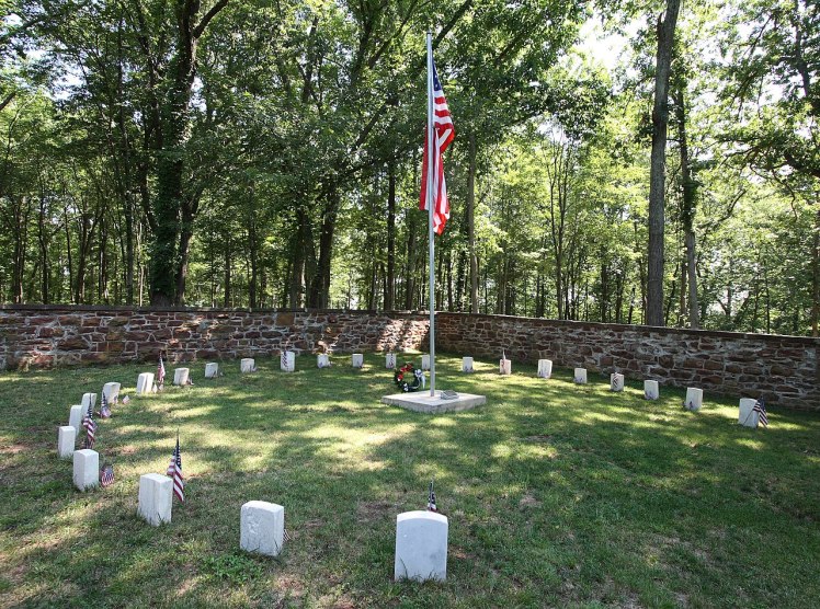
Ball’s Bluff National Cemetery – photo from Wikipedia – it is one of the smallest National Cemeteries in the country
Other than Harper’s Ferry, this was the ONLY fighting to have occurred on the Potomac. Further south from the golf course is Great Falls National Park, where the river squeezes itself into a gorge. The Army Corp of Engineers dammed part of that up to supply fresh water to D.C. just before, during and after the war. Other than that, the river was used for transport and served only as a major obstacle in the maneuvering of both Confederate and Union Armies. It never ran red with blood. Bodies floated downstream towards D.C. after Ball’s Bluff but that’s it.
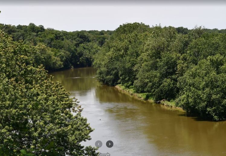
Current photo of Harrison’s Island on the left and the Potomac. Take from the bluff on Edward’s Ferry Road
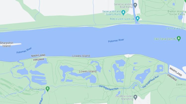
Now the golf course does sit on what used to be Lowe’s Island – created by a “slough” or a channel. The island is large and was an attractive crossing point in the river. It served as a staging area for both armies on occasion and in June, 1863 JEB Stuart and his cavalry crossed near the island, trailing Lee’s Army on his way to Gettysburg. He skirmished briefly with Union troops across the river near Seneca, MD after effectively stealing a wagon train full of Union supplies, but that’s it. By July of 1863, it was being used as a storage area by Confederate irregulars and thus was “cleared” by General Doubleday and the 4th NY Artillery – no casualties listed in the report. I suspect they just blew hella stuff up. The only other incident that is remotely noteworthy, and is honestly closer to nothing than noteworthy, happened in November 1861 – after the rout at Ball’s Bluff. General McCall was still around the Dranesville area and by November, was stationed at Camp Pierpont. Dranesville is maybe a mile south from Lowe’s Island. Maybe. Camp Pierpont was in Langley, due east from Dranesville. On November 27, McCall received a note listing citizens who attacked 4 soldiers from the 34th NY Infantry, killed 2 of them, stripped them and left them for hogs to devour. The suspects were residents of the Dranesville area. They obviously didn’t like Union soldiers being in Virginia. And the soldiers were apparently stragglers. Who knew?
On December 6, General George Meade set out to Dranesville to arrest John Gunnell’s nephews for the crime, despite the fact that they are not on the list of suspected citizens provided by John Hawkshurst, a local civilian and Unionist.
“The following is a list of the citizens that attacked four of our men on Lowe’s Island, killing two of them, and stripped and left them so that the hogs ate them: Dr. William B. Day, Dr. John Day, Thomas Carper, John Coleman, Gilson Jenkins, Samuel Jenkins, Thomas Coleman (who now has one of the pistols taken at that time), James Farr, Philip Carper, James Carper and Stephen Farr. They are all residents about Dranesville. This information was furnished by three of Mrs. Coleman’s negroes who came into Camp Griffin November 26, 1861.”
While he succeeded in the arrest of the nephews and in foraging for the army, Meade was disappointed in his men and wrote to his wife that his men were so ready to punish rebels that they had to to be kept from burning what wasn’t carried away.
So the “River of Blood” that is the Potomac River at Lowe’s Island amounts to 2 unknown soldiers, killed by citizens and eaten by hogs.
How about this for a plaque? And really, I’m trying to be nice here. I didn’t mention the hogs.
LOWE’S ISLAND
Formed by an old chute of Sugarland Run and used as a staging point by both the Union the Confederate Armies during the Civil War. General JEB Stuart crossed near here on his way to Gettyburg in late June 1863 and skirmished with Union troops after commandeering a Union supply train near Rockville. Used by Confederate irregulars for storage and livestock, it was cleared by General Doubleday and the 4th NY Artillery in July 1863. The island sits opposite what is now the remains of the C & O Canal which was a vital transport lane for all manner of things including coal for the nation’s capitol. Canal boats and mules would have been fiercely guarded by the US Army during the Civil War and it was used to transport not only vital war materials but troops as well.
Boys from NY cleared the island that is now your golf course. Using REALLY big guns. That should make you happy Donald. Bigly.
Now grow a pair, admit the mistake and at least be accurate about the plaque.
